BRATTLEBORO — Multiple Vermonts in every color of the rainbow line the walls outside Academy School's fourth-grade classrooms.
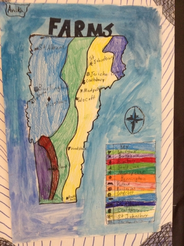
Some maps depict the location of animal shelters in the state, others have ski areas, while still others show the location and types of wild animals or organic farms.
What the maps have in common, despite the recognizable key-hole shape state, is that they depict the creativity, research skills, and interests of the school's three fourth-grade classes.
The students created their maps through a workshop developed by local artist Mollie Burke called “Maps by Hand: The Land, History, and Culture of Vermont.”
She worked with 50 students for 10 days starting in April until the school's “mini gallery walk” on June 15.
As students excitedly dashed past, Burke, a Progressive/Democrat who represents Brattleboro in the Vermont House, said that “being in the Legislature gave me an even greater context into the land, history, and culture of Vermont.”
Together, Burke and students studied the landscape, culture, and history of the state while learning about maps. Students learned how to find a location on a map by following the lettered and numbered grids. They deciphered map keys, and compass roses.
Next, students picked a topic of interest like wildlife, Civil War battles, pancake houses, or farmers' markets. Finally, students depicted their chosen topic on a map of their making.
The Vermont Arts Council fully funded the workshop as part of its Artists in Schools program, with a $2,500 grant.
Fourth-graders streamed out of their classrooms and piled in front of the maps. Friends showed their maps to each other. They raced from one huddle of students to another. Students showed off their creations to their teachers.
The workshop taught skills beyond locating Vermont's major cities on a map.
“Definitely, they [students] rose to the challenge,” said fourth-grade teacher Kate Rabideau.
According to Rabideau, fourth-graders at Academy study Vermont history, geography, and culture at the start of the academic year. The workshop gave them the opportunity to revisit what they learned.
“With a project like this, the kids who don't normally step forward really did,” she said, adding that gave the opportunity for engagement to students who characteristically sit back and “let things happen to them.”
Burke concentrated most of the workshop's 10 days into last week, Rabideau said. This created goals and project deadlines.
“It's a huge skill,” she said. “Especially at this age when deadlines are becoming a part of their learning.”
Fellow fourth-grade teacher Kim Brenton remarked that her students displayed huge amounts of creativity in their maps.
“It was a fun project to see what Vermont has to offer,” she said.
The project allowed them to use all their senses and skills, she said. “Just to have that creative freedom was nice.”
Stretching their creative muscles came with academic benefits, she said, because the workshop required that students take what they read, researched, or saw and transform that information into a visual representation.
Brenton said this process helped students develop a higher level of learning, analytical thinking, and problem solving.
The students ended their mini gallery walk by reciting the Vermont state song, “These Green Mountains.”
Burke complemented the students on their maps.
“You all worked hard,” she said. “And I hope you want to learn more and more and more about Vermont.”
Amidst a chorus of “Thank you Miss Mollie!” Burke stopped to take photos of the maps.
“Old maps are works of art,” she said.
She said she hopes the students leave the workshop with a greater understanding of art, geography, history, and cartography.
Burke delivered the Maps by Hand workshop to a number of schools over eight years.
The project has its roots at Hilltop Montessori School in Brattleboro.
Burke taught landscape drawing and created topographical maps with students. The kids would mark where on the topographical map a funny event occurred, such as where they dropped their lunches, said Burke.
Maps by Hand took shape after an invitation to a conference in the Statehouse - before Burke's days as a state rep - by author and teacher Elise Guyette.
“It was nice to do the project so close to home,” Burke said.
She added that completing the project weeks after the end of the legislative session also made her feel connected to her work as a legislator, students, and Vermont.