TOWNSHEND — Weather buffs and amateur radio operators - who are sometimes the same people - received a treat in early April: training in how to see severe weather coming, and how to report it, from National Weather Service (NWS) Meteorologist-In-Charge Raymond O'Keefe.
Every spring and fall, the Albany office of the NWS conducts Skywarn spotter trainings throughout their service region to engage citizens in helping report severe weather events. Windham County's seminar was held at the Grace Cottage Hospital.
During his presentation, O'Keefe offered instructions on best practices for spotters, shared weather statistics, showed scary videos of tornadoes and lightning strikes, and told stories even a non-self-identified weather enthusiast might enjoy. There also was a quiz at the end of O'Keefe's talk. The group scored 100 percent. The homemade cookies served to attendees may have fueled their success.
O'Keefe gave each attendee a sheet with Skywarn reporting criteria, the Beaufort Wind Scale, standard hail sizes, and a Weather Spotter's Field Guide.
The guide, published by the U.S. Department of Commerce, which oversees the NWS, says the Skywarn program was developed in the 1960s, and “consists of trained weather spotters who provide reports of severe and hazardous weather to help meteorologists make life-saving warning decisions."
O'Keefe told attendees about recent investments the NWS has made in technology to better predict the weather. He said his employer has “the 40th-fastest computer in the world,” plus new satellites, work stations, and Doppler radar.
“The Doppler radar is a fine piece of equipment,” O'Keefe said, “but it can't tell us how much snow fell.”
The NWS needs spotters because “we prefer someone to tell us how big that hail was,” he said. By the time a representative from the NWS arrives at a location, “the hail has melted,” O'Keefe said.
When reporting hail, O'Keefe suggested comparing the size to something standard: a pea, a penny, a pingpong ball. “Don't report hail as marble-sized!” he urged, then showed a slide of four different marbles of varying sizes. Better yet, O'Keefe said, place the hail next to something of standard size, such as a dollar bill, and take a photo with your cellphone.
In addition to reporting how much snow fell and how big the hail was, spotters' tasks include notifying the NWS if lightning or high winds caused property damage, personal injury, or death, if trees fell during a storm, if they saw a tornado, funnel cloud, or wall cloud, if freezing rain fell, or if more than about one or two inches of rain fell in an hour.
The spotters' data helps the NWS verify its severe weather warnings and ensures accuracy, O'Keefe said.
It also helps keep warnings current and relevant.
O'Keefe gave the example of tornadoes. Although they are rare in Windham County - we average one tornado watch per year - the lead-time here is half of what it is nationally.
He explained why: Most of Vermont's tornadoes are weak and short-lived, making them difficult to see on the radar. Sometimes the NWS doesn't know a tornado touched down until it receives spotter reports. That means “sometimes we get zero lead-time,” O'Keefe said. According to a guide published by the National Oceanic and Atmospheric Administration (NOAA), the current average lead-time for tornado warnings is 13 minutes.
Storm chasers need not apply
During the training, O'Keefe dashed the hopes of any attendee who might have arrived seeking information on becoming a storm chaser.
“Safety is paramount as a spotter,” O'Keefe said, noting the weather observations will best and most safely happen “when you're looking out your window. You're not really driving in your car, out chasing severe weather.”
Plus, he added, “it's kind of hard to do in Vermont.”
O'Keefe offered measuring wind speed as one example of the importance of safety: “Don't stand there when branches are flying off the trees. You should be in the basement.”
He assured attendees they could provide wind-speed estimates by examining their surroundings once a storm is over by using the Beaufort Wind Scale, which he provided. For example, if broken-off or uprooted trees and bent or deformed saplings are observed, wind speeds were likely between 55-63 mph.
Attendees also received instructions on a variety of cloud formations, including those that are likely to bring severe weather, such as wall clouds and shelf clouds, which are often associated with derechos - widespread wind storms.
“If you're driving toward a shelf cloud,” which is a low, horizontal, banded cloud with a turbulent, wind-torn underside, “grip the steering wheel, because you're coming into some very high winds,” O'Keefe warned.
When an attendee asked O'Keefe if lightning is the most-frequent weather-related cause of death, he said no.
Heat-related trauma might be No. 1, O'Keefe said, but sometimes weather isn't to blame for the fatality, such as when a person suffers a heart-attack from working too hard outdoors on a hot day: Would that heart-attack have happened without the heat and labor?
O'Keefe said the NWS's recent campaign to alert the public to the dangers of lighting has led to what he calls “a substantial decrease” in lightning fatalities.
But, “be weather savvy,” he cautioned, reminding attendees there really is no safe place outdoors during a lightning storm, so it's wise to check weather reports before planning a fishing or hiking excursion.
“If you hike up Mt. Mansfield and a thunderstorm comes, you're in trouble,” he said. Likewise if you are in a boat on a lake.
Meet the weather spotters
A number of attendees at O'Keefe's presentation were part of the West River Radio Club, an organization made up of local amateur, or “ham,” radio operators. The club, whose website is at www.westriverradio.org, welcomes amateurs and provides training, events, and camaraderie.
They also provide a valuable public service.
In an email to The Commons, West River Radio Club President Timothy Bell (call sign “KA1ZQX”) said, “Amateur Radio Operators have had a unique relationship with the NWS for years. We gather weather information and forward it directly to the NWS in a timely manner.
“They can count on our information as correct as we have had training in their reporting criteria. Our club has partnered with the weather service for the 12 years we have been in existence by sponsoring local weather-spotter training each year.”
“I am a Skywarn spotter and have been for over 20 years,” he said.
Most club members are Skywarn spotters, Bell said, “as this is a good fit for their day-to-day activities if severe weather develops. Should any All Hazards events happen, we can relay the weather information from the field to the NWS via amateur radio directly to the office or to another Skywarn spotter member who can relay it to them via radio or phone."
“Being the 'boots on the ground' relaying what is happening at that specific moment is valuable information to the NWS, area emergency directors, and the Vermont Division of Emergency Management and Homeland Security based in Waterbury,” Bell said.
When asked to name notable weather-related events in which he and other club members have assisted, Bell listed some of the worst storms in recent memory.
“The blizzard of 1993 and 1996, the Grafton flash floods of 1996, and Tropical Storm Irene of 2011 are just a few [in which] we have performed our duties. Our reporting practices and procedures are perfected each year we perform our duties. Sometimes what we do is second nature as it just becomes another way of life. We serve our communities each day we turn our radios on,” Bell said.
“It's not just a hobby, it's a service,” he noted.
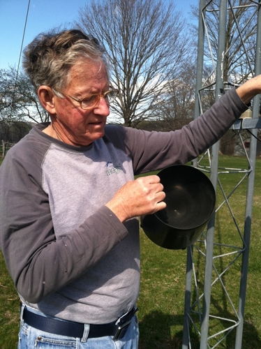
Allan Seymour, who was also at the NWS Skywarn training seminar, isn't a ham radio operator. His connection to the weather is through his participation in the Citizens Weather Observer Program (CWOP). His station number in the CWOP network is CW1490.
Seymour has been collecting weather data on his own for over 30 years, he said, and has been part of the CWOP for 10-12 years. Since 2004, he has sent data to the Weather Underground website (wunderground.com); his designation in the WU's network of personal weather stations is CT River Valley KVTEASTD4.
Behind the Dummerston home that Seymour shares with his wife, Sally, there stands on a flat parcel of land a 33-foot tall metal structure that looks like a beefed-up antenna. At the top is an anemometer, which measures wind speed, and a wind vane that displays direction.
Closer to the ground, at five feet, is a solar-powered console that serves a number of weather-related purposes. One device measures how much solar energy is falling on the ground, expressed in watts per square-meter.
A black plastic rain bucket suspended by a rack reveals how much rain has fallen; every time the bucket tips, letting out a drop, it measures 1/100th of an inch.
All of this data is sent via wireless antenna to a Davis Vantage Pro weather station sitting on a shelf above a computer in Seymour's kitchen. From there, Seymour said, his weather data is transmitted via the internet to the CWOP every 30 seconds.
Seymour's data “goes into a big server with everybody else's information, and that gets sent to the NWS” via the Meteorological Assimilation Data Ingest System, which combines data from NOAA and data from citizen providers, he said.
“They take my data and check it for errors,” Seymour said, because “if everybody's messing up and sending garbage, that would be no good.”
Collecting the weather isn't part of Seymour's profession. “It's just a hobby,” he said. “I'm fascinated by what's going on around us. I have fun with all of this."
“I don't forecast” the weather, Seymour said. “I only observe.”