BRATTLEBORO — Nearly five years ago, Tropical Storm Irene's floodwaters tore through downtown in a matter of hours.
But the experience triggered a new focus on creating resilient communities, a priority that will unfold over decades.
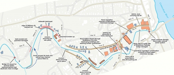
Earlier this month, the Town Planning Department unveiled some new measures for a section of the Whetstone hardest hit by the 2011 flood, opening the process for public comment.
As part of its Smart Growth Implementation Assistance program, the U.S. Environmental Protection Agency (EPA) hired a team of design firms to fold these concepts into a vision plan.
The plan covers the area of town along the Whetstone Brook, starting at the Preston Parking Lot near the Latchis Theatre on Flat Street, continuing along Frost Street and Frost Place, and ending at a 12-acre parcel of open land between Williams and Estey streets.
According to Planning Director Rod Francis, Brattleboro needs to find ways to “give flood water more room to move around.”
The amount of flood damage from a storm depends on the water's volume and velocity, Francis explained.
Landscape and building designs can mitigate some damage, and the plan includes features to reduce the negative impacts of flooding on downtown.
Little in the plan is slated to be implemented any time soon. But Francis described a vision for the area, most of which lies within a flood plain, as “a real culture shift.”
“This is all doable,” he added.
First impressions
According to Francis, participants viewed and commented over three days on designs by the team of landscape architects and planners from three firms: Parker Rodriguez, Inc. of Alexandria, Va., Wagner Hodgson Landscape Architecture of Hudson, N.Y. and Burlington, and Watershed Consulting Associates, LLC.
Approximately 120 people participated in the process, held June 6 to 8 at 118 Elliot.
Dennis Carmichael, principal at Parker Rodriguez, said he loved getting immediate feedback on the designs.
“You get the bad ideas out of the way in a hurry,” he said, adding that for any of the designs to work, they had to work for the community.
Carmichael and other team members edited the designs based on participants' feedback each day of the event.
The EPA's competitive program provides direct technical assistance, like the team who conducted the visioning process, to communities looking to redevelop areas while protecting environmental resources.
Francis said town employees and EPA staff had previously built relationships through the town's Brownfields Program, which administers a $400,000 EPA grant to restore contaminated industrial properties for reuse.
Given the town's potential issues with flooding and water management, the town was also a good candidate for the smart growth program, he said.
These types of programs also help keep the town compliant with state and federal regulations, he said.
Strategies to avoid flooding
The vision plan offers features and design guidelines like:
• Turning parking lots into green spaces that can absorb or slow down water.
• Moving structures from the flood way, where water flows fastest in a flood.
• Installing easy-to-maintain infrastructure, like a bike path, along the river's edge, and surfacing such paths with material that allow water to drain.
• Building homes with parking underneath so that the living area is 1 foot above estimated flood levels.
In interviews with The Commons after Irene, state river engineers stressed that rivers need space to spread out and slow down.
Left to their own devices, said the engineers, rivers will shift their banks over time through erosion and dropping of sediment.
Healthy rivers, said the engineers, contain S-curves and an alternating pattern of rapids and slow-moving water. This natural dynamic balances the water's power, keeping it from moving so fast it erodes everything in its path, but fast enough that it doesn't turn into a pond.
Despite the rivers' need for room to move, shift, and change, most towns were built close to the waterways that powered the manufacturing of the Industrial Revolution in the 1800s.
As a consequence, human-made structures crowded and hemmed in their rivers. Banks have lost their S-curves. Water flows faster. River channels dig deeper.
And when the river floods, it has nowhere to go but smack into the human-made structures.
A model for other towns?
Windham Regional Commission Executive Director Chris Campany attended the event.
He wrote in a later email that coastal communities have dealt with flooding issues and resilient design for years and said it's good that Vermont has started to prepare for the same issues.
Other towns could learn a lot from Brattleboro's visioning process, he added.
“I think it's great the town recognizes and accepts the risks posed by more-frequent and greater-magnitude flood events, and that they're engaging in a process which approaches this as an opportunity for community development that treats the Whetstone as an asset,” Campany wrote.
He thought the process's designs helped “better connect neighborhoods and make the Flat Street and Frost Street area of downtown a more vibrant and exciting place, and which proposes redevelopment that both restores access to the floodplain by the stream and floodwaters while simultaneously creating an opportunity for housing and commercial development that would respond to the flood risk.”
“The details need to be fleshed out, but it's an exciting vision to be pursued,” Campany wrote.
Francis echoed Campany's comment. He cautioned the community that the plans, while detailed, represent the possible at this point.
Parts of the corridor under town ownership can be redeveloped within five years, he said. Other areas will undergo redevelopment over decades as the community and ownership changes.
For example, Francis said, parts of the corridor are under private ownership. The town won't develop these areas unless the private owners decide to sell, he said.
“It's up to them [the private owners] - entirely up to them,” Francis said.
Meanwhile, the town's designs stand at the ready.