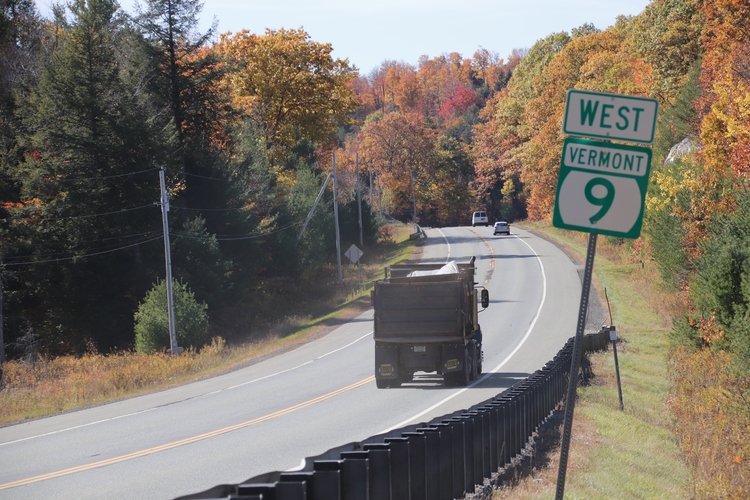
BRATTLEBORO — The Agency of Transportation intends to repave 12.5 miles of Route 9 between Wilmington and Brattleboro starting in 2021, an undertaking described by the state agency's program manager, Jesse Devlin, as “one of the more complex projects” on the horizon.
The $14 million project was discussed Oct. 4 at a meeting organized by Windham County lawmakers, who invited AOT staff to Marlboro to hear from a group of citizens concerned about southern Vermont's primary east-west travel corridor.
There, community members shared concerns about a number of issues, including truck traffic and safety, especially near Marlboro Elementary School.
Devlin, the agency's highway safety and design program manager, is heading up the early stages of the project.
In a conversation with The Commons recounting the meeting and discussing the plans for the road, he said the “longer, linear” project is handled through AOT's paving program and will focus on the “surface condition” of the road, last paved in 2002 and 2003.
This means contractors will repave the road and address some safety issues and other road conditions when possible, such as increasing shoulder width on either side of the roadway or altering road striping.
Where the contractors can increase the width of the road, they will try to create 11-foot lanes with 4-foot shoulders, according to Devlin.
Increasing the road width should help drivers feel less pressed up against other cars or trucks, he added.
The AOT classifies Route 9 in Brattleboro and Marlboro as “fair,” “poor,” and “very poor.”
Ready to rumble
The project will include the addition of center rumble stripes where necessary.
According to Devlin, rumble stripes - sometimes called rumble strips - “are an important safety benefit.”
AOT has changed its process for deciding where the rumble stripes go.
Devlin called the rumble stripes on Route 9 “vintage,” adding they were some of the first applied in Vermont.
The agency has changed its process for deciding which roads could benefit from the stripes, he said. For example, the rumble stripes are installed in areas of the road where speeds are higher, the roads are wider, and residences are built more than 100 feet from the roadway.
Staff have also changed the stripes themselves, which Devlin thinks were carved deeper into Route 9 compared to newer ones in subsequent road projects.
Widening the road is not possible in all areas of Route 9, he added. In some areas, the road travels close to unmovable landforms such as ledge and to waterways such as the Deerfield River and the Whetstone Brook.
Route 9 is a tricky road, he said - but that's “true of a lot of roads in our state.”
The project, however, won't tackle big changes such as straightening the roadway, he said.
The AOT has no authority over truck traffic and thus no authority to prohibit trucks from using Route 9, Devlin added.
Project could take two seasons
According to Devlin, the project is in the early design phase. Construction is expected to start in the calendar year 2021, following a successful permitting and bidding process.
Devlin said that, because of the number of miles the project will cover and the road's complexity, Devlin said the agency has not set an end date.
“It could go for two seasons,” he said. “This is a major transportation project. The agency will do its best to minimize impacts, but there will be impacts [for drivers].”
As the project develops, AOT staff will reach out to local communities and their Selectboards to minimize disruptions.
If necessary, the agency can work certain conditions into its project contract, such as times of day when contractors can start work.
Devlin cautioned that the agency would want to avoid creating too many limitations, which would stretch the project's timeline.
A long road, a long history
Route 9, officially designated the Molly Stark Trail through the entirety of its length in Vermont, “follows the path carved out in 1777 when, after the Battle of Bennington, General John Stark and his army returned to New Hampshire via the nearest passage, essentially the same track as today's Vermont Route 9,” according to one description of the route.
In 1762, the road linked Bennington to Wilmington, and extended to Brattleboro by 1802, creating the Windham County Turnpike.
“The new road was a primary route for six-horse freight teams that travelled the mountains from Brattleboro to Bennington to Troy, New York, and then to the Erie Canal,” according to a history on the Molly Stark Byway's website.
The road was assigned its route number when it was incorporated into the New England road marking system in 1922. Almost a century later, it is one of the longest highways in New England to retain a single route number. It was named a state highway in 1931.
The road itself starts at the Maine–New Brunswick border, and passes through the Maine cities of Bangor, Augusta, and Portland.
It cuts across southern New Hampshire from Somersworth on the seacoast to Chesterfield before it crosses the Connecticut River and becomes the main east-west route in southern Vermont between Brattleboro and Bennington. It then crosses into New York state, where it becomes Route 7.
The Vermont portion of the road is 46.96 miles long. It was designated as a scenic byway through the federal National Scenic Byways Program in 1995.