BRATTLEBORO — A walking path, a kayak launch, a public restroom, and an outdoor amphitheater: those are a few of the design features unveiled by the Hinsdale-Brattleboro Existing Bridges Subcommittee.
The group is charged with defining what the Brattleboro and Hinsdale, N.H., communities want for Hinsdale Island (more universally know as “the Island”) and the walkway that will replace the current stretch of Route 119 after the new Hinsdale-Brattleboro bridge is completed.
“Very early on in our work we set out some goals for what we though would be useful for the vision,” said subcommittee Co-chair and Brattleboro Assistant Town Manager Patrick Moreland. “We wanted to make sure that we had a vision which could strengthen the social and economic relationship between the two states and the two communities.”
Also included in the goals that Moreland listed: promoting outdoor recreation, providing more opportunities for people to access the river, and ensuring the area is safe and clean, all while remaining cost effective and preserving what he called “the integrity of natural, historic, and cultural resources.”
The subcommittee was formed by the Hinsdale-Brattleboro Bridge Project Advisory Committee, a citizen advisory group that provides guidance to the New Hampshire Department of Transportation (NHDOT), the Vermont Agency of Transportation (AOT), and the towns of Brattleboro and Hinsdale.
The new designs for the Island and the current bridges - the Anna Hunt Marsh Bridge and the Charles Dana Bridge - mark a year of public input to the subcommittee. Last March, its members held a site visit followed by a public survey and meetings with various state entities.
Subcommittee members include representatives from the residents and local officials of Brattleboro and Hinsdale, the Southwest New Hampshire Regional Planning Commission (SWRPC), and the Windham Regional Commission.
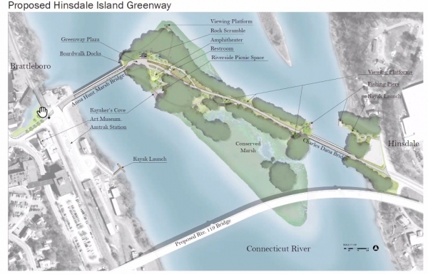
The designs presented at the April 1 online meeting were created by Christopher Ramage, a master's degree candidate at the University of Massachusetts at Amherst Department of Landscape Architecture and Regional Planning.
“It's a really unique site,” Ramage noted, adding that the bridges connect the “urban-feeling” downtown Brattleboro to the forests around Mount Wantastiquet. “So we run the whole range of place types within this one site, and that leads to great opportunities to create rich experiences.”
Ramage told the audience that his initial designs attempted to balance outdoor recreation with environmental conservation.
Moreland said that details, such as construction and maintenance costs, will be determined.
Hinsdale Selectboard member Bernie Rideout, and a few of his fellow residents, made their desires very clear.
They supported the project, but they absolutely did not want for Hinsdale to shoulder the cost of the project or the responsibility of maintaining the new infrastructure, a sentiment they expressed several times throughout the meeting.
New Hampshire state Rep. Michael Abbott, D-Hinsdale, noted that the bridges and the Island fall under the jurisdiction of the state of New Hampshire, not the local government of Hinsdale.
Breathing new life into old steel
Repurposing the two steel bridges for outdoor recreation is part of a $50 million bridge construction project.
The New Hampshire Department of Transportation is leading the project with support from the Vermont Agency of Transportation. The two states intend to build a new, approximately-1,800-foot, single-span bridge downstream from the current bridges, which no longer meet current transportation needs and modern safety standards.
Construction of the new bridge is expected to be completed in 2024.
Overall, the members of the public who spoke supported the plans for the existing bridges.
According to Ramage, cultural activities and education, recreational opportunities, and environmental conservation were important aspects to consider when designing the project, based on public feedback.
Members of the public also shared that they wanted to participate in activities such as swimming, boating, and fishing, as well as to watch live performances, view wildlife, and have picnic tables to eat at the Island and its connecting bridges.
Most of the new infrastructure that Ramage designed, such as the amphitheater, picnic area, and kayak beach, would be built on the western (Vermont) side of the island, closer to the Marsh bridge.
The more eastern (New Hampshire) side of the island, near the Dana bridge, would be preserved for wildlife and plant life, including an existing wetlands.
An existing bridge pier would be transformed into a fishing area. The walking and biking trail would follow the existing Route 119 corridor, which Ramage called “the spine” of the project.
Ramage's designs also include building a kayak launch on the Brattleboro side of the river that would be accessed through the Depot Street parking area.
Existing river access on the Hinsdale side of the river could be used for additional pull-off spots, said Ramage, noting the potential to use some of the parking lot of the Shoppes at George's Field in Hinsdale.
While the bridges and Island will be reserved for pedestrians and cyclists, the area will remain accessible to emergency services.
Ramage suggested three types of lighting to illuminate the path from one side of the river to the other. Small LED lights (of any color) could outline the bridges' arches, he said.
Lighting on the island part of the path would be a mixture of pole lights and bollard lighting. Ramage said that the wattage would be set low enough to reduce light pollution yet bright enough to maintain safety.
Ramage said he took potential flooding and ice floes into consideration when designing the infrastructure for the island.
In the case of what the Federal Emergency Management Agency considers a 100-year flood, he said the pathway would still remain above the water level.
He likewise kept most of the relatively fragile built infrastructure, such as the potential restroom and lighting, above the 100-year-flood water line. He did note that in the case of what FEMA considers a 500-year flood, the entire island would be below the water.
When asked if the public restroom would be plumbed or use composting, Ramage said current thinking and regulations point to composting as the better option. But, he added, this could change.
Alice Charkes, who identified as a cyclist, said she'd like bike riders and pedestrians to be given separate paths to travel on, asserting that commingling the traffic is unsafe for both.
Ramage thanked Charkes and said he would look at the issue. Currently, the bridges are 15 feet wide, and the pathway is 12 feet wide at its most narrow point.
Details TBD
According to the Hinsdale Island project timeline, final designs are due to the Existing Bridges Committee in early May.
According to NHDOT Project Manager Donald Lyford, the last time he checked, seven general contractors had submitted bids to build the new single-span bridge that will connect Hinsdale to Brattleboro at Vernon Street. Contractors have until Thursday, April 22 to submit their bids.
Moreland explained that work to refurbish the existing bridges is included in the scope of the larger Brattleboro-Hinsdale Bridge project. Work on the Island is not, meaning that the subcommittee's work is only the beginning for this aspect of the project.
The subcommittee's charge is to develop the Island and pathway's designs and incorporate public feedback. Cost estimates, budgeting, and permitting will come after the subcommittee submits its final report, he said.
Moreland stressed that it remains a huge unknown which entity will finance, construct, and maintain the project.
“We're trying to build an idea that's supported by the community,” said J.B. Mack, subcommittee member and principal planner with SWRPC. “We have a target as to what the communities can do with this space in the future.”
He added that the subcommittee's final report will go to the local Selectboards, interested state entities, and other interested “stakeholders” that might be interested in the project.
“None of this is set in stone,” Mack said.