BRATTLEBORO — A new Downtown Plan proposes more public spaces and to upgrade many existing sites, with a goal of making downtown a calm lagoon where people and businesses rest, mingle, and engage, rather than slide through carried on a crisscrossing road network to somewhere else.
Establishing a public restroom. Developing Harmony Parking Lot into a people-centered space. Updating the Preston Lot to take advantage of the green space around the Whetstone Brook.
These are just three of the priorities outlined in the plan, released to the public last week and available at bit.ly/618-downtown-plan.
The town will also host multiple public sessions throughout the summer around the plan, the Planning Commission announced in a press release.
“Brattleboro's downtown was not built around a planned network of public spaces,” explains the plan, developed by a team that included PlaceSense, based in Windsor; Park Architecture of Hanover, N.H., Stone Environmental in Montpelier, and MAKE Architects, also of Hanover, N.H.
“Some parks were developed as a result of redevelopment, finding small spaces here and there as the opportunity presented itself, while other parks found their size and accessibility cut off as a result of transportation projects,” the planners continued. “Buildings were built along significant natural features - the Connecticut River and the Whetstone Brook leaving little room for trails and parks.”
Qualities of a good public space include features that make it welcoming, accommodate everyone who uses it, and fosters social interactions, according to the plan, which also says that a public space should be safe, be well-lit, and offer multiple activities. Finally, a public space should also be visually pleasing, reflect its environment, and be maintained.
Good public spaces can also create safe crossing areas for pedestrians, deter crime, and offer flexible uses, alternating between formal and informal event or gathering space for the community.
Good public spaces are also “characterized by the presence of people remaining when they have no pressing reason to stay,” states the plan.
Downtown's northern border, as defined in the plan, stretches across Terrace Street to the Connecticut River, which makes up the area's eastern border. The downtown area then extends south to Depot Street and the Amtrak station. The western edge snakes around the commercial areas of Elm, Flat, Elliott, and High streets on its way back to Williston Street.
According to the planning team, more than 700,000 square feet of commercial space is in use downtown. Almost all the stores and restaurants are locally owned, and more than 600 people live downtown, they add.
Most of the downtown's buildings were constructed between 1840 and 1900, according to the plan.
“Downtown Brattleboro of 150 years ago would be largely recognizable to us today,” wrote the design team. “The basic street network in downtown Brattleboro was established by 1820 and remains essentially unchanged to the present.”
An anticipated change in traffic patterns due to New Hampshire's $50 million Hinsdale-Brattleboro Bridge Project was one impetus behind completing the Downtown Plan, wrote the plan team.
The New Hampshire Department of Transportation, with support from the Vermont Agency of Transportation, will build an approximately 1,800-foot, single-span bridge downstream from the Anna Hunt Marsh and Charles Dana Bridges, which currently connect the two states.
Guiding principles
A 2019 Municipal Planning Grant from the state Department of Housing and Community Development provided partial funding for the process.
Listed in the plan are guiding principles for future efforts. Topping the list is improving access for pedestrians and cyclists and fostering the long-term economic stability of downtown businesses.
The plan also calls for boosting public spaces by encouraging artistic and cultural creative placemaking.
In the 2021 legislative session, Rep. Sara Coffey, D-Guilford, helped shepherd legislation and grant funding for the state's Better Places Program.
“Creative placemaking projects are more than just painting an alleyway or creating a new plaza,” Coffey told The Commons. “But it's really about community engagement and creatively envisioning what you want in these spaces, so that they are all inclusive and inviting spaces for the community.”
Increasing resiliency by establishing green stormwater practices and landscaping on the streets and public spaces is also on the lists.
During heavy rains, sections of the downtown will sometimes flood temporarily. For example, the stretch of Main Street between High and Grove streets will often quickly fill with water and make a de facto moat in front of the post office and Centre Congregational Church.
According to Public Works Director Steve Barrett, parts of the downtown's stormwater system are more than 100 years old and predate many of the downtown's buildings and paved surfaces.
These impervious surfaces funnel more runoff into the municipal stormwater system than it was built to handle. The current system also channels unfiltered stormwater directly into the town's waterways.
The town must also comply with new clean water programs related to Act 64, which the Legislature passed in 2015. State agencies are phasing in related permitting programs such as the Department of Environmental Conservation's Stormwater Management Program, which also oversees runoff programs related to municipal roads.
Past surveys, past planning
The Downtown Design Plan builds off past surveys, studies, and public events. Feedback from previous work is one reason the design team chose to focus on improving public spaces.
In 2019, the town held the Better Block Challenge, which consisted of three pop-up projects placed in traditionally underused areas of the downtown.
It followed up with Places for People charrette, where design professionals and community members discussed areas of the downtown, their challenges, and potential solutions.
In a 2019 Public Space survey, the words community members used to describe the downtown ranged from “lively,” “quaint,” “beautiful,” and “vibrant” to “run-down,” “unsafe,” and “unaffordable.”
Survey respondents also said that the downtown parks did not offer places for community members to sit, rest, talk, or play.
“There is no space to be, no reason to be doing anything except passing through,” one design plan respondent said. “The public spaces are not destinations for pleasurable gathering or hanging out.”
Those who responded to the survey also showed a preference for more green space.
One study of the downtown referenced in the design plan noted that the area's layout prioritized vehicles over the movement of pedestrians or cyclists. Attributes like on-street parking, narrow sidewalks, and hilly topography can make walking or biking through the downtown difficult, noted the master plan.
Many perceive the downtown as cramped and overrun by road traffic, observed the design team, saying that more than 15,000 vehicles pass through the downtown daily. Despite the sense that downtown is congested, traffic on Route 5 has declined since the 1980s, they noted.
This observation was reinforced through data collected in a 2017 parking study that found that ample parking is available in the downtown, yet noted that many feel there is nowhere to park or feel uneasy about parking in some areas.
For example, more people prefer parking in the Preston Lot on Flat Street than the nearby Brattleboro Transportation Center, which is less expensive.
The design team wrote that some of this response is because of people's perceptions of the parking garage. But it is also a sign that the pedestrian routes that connect different areas of downtown need improvement, they observed.
“Are there ways to improve the connections through downtown for pedestrians and bicyclists?” asked the design team.
Previous studies also pinpointed the limitations of the municipal stormwater system.
Six public parks and three public buildings
The six areas designated as public parks are Wells Fountain, at the foot of the Windham District Court lawn; Pliny Park, which sits at the intersection of High and Main streets; Church Street Park, overlooking Elliot Street; Whetstone Pathway, originally designed to stretch along the Whetstone Brook but whose only completed area borders the Brattleboro Food Co-op's parking lot; Plaza Park, at the intersection of Main, Canal, Vernon and Bridge streets (also called “Malfunction Junction”); and Depot Street Riverfront Park, the green space near the Connecticut River bridges.
Three public buildings on Main Street have enough outdoor space that could function as additional parks: the Municipal Center lawn, the terrace and garden of Brooks Memorial Library, and the lawn of the Gibson-Aiken Center.
The design plan outlines strategies to improve these areas along with changes to the streetscape. It breaks the downtown into three areas: the Way Around, Main Street, and the Intersection (Malfunction Junction).
According to the design team, the Way Around would connect public spaces, mostly on the west side of the downtown. This interconnectedness would provide pedestrians - and cyclists specifically - a way to travel through the downtown area while avoiding the vehicle traffic on Main Street.
The Way Around could also serve to connect people using the trails at Mount Wantastiquet in New Hampshire to the West River Rail Trail that originates at the Marina Restaurant, stated the design team.
In between, the Way Around would thread people past and connect them to eight new public spaces and improved existing ones: Brooks Memorial Library (“a community space on the street”), Pliny Park (“a central open space in the heart of downtown”), the Bridge Street Woonerf (“a shared space for pedestrians, cyclists, and motorists”), Harmony Park ("a space to meet and hang out"), Riverfront Park (“a space to play and enjoy the view”), High-Grove (“a pleasant space to traverse”), Whetstone Pathway (“a welcoming and activated space”), and Preston Park (“a restored green space”).
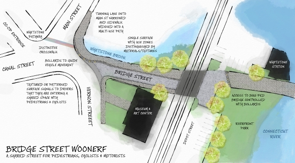
In one of the more ambitious proposals, the plan calls for Bridge Street to be “transformed from a high traffic through street to low traffic dead end street when the new bridge opens - creating the opportunity for Bridge Street to become a space primarily designed to accommodate pedestrians and cyclists, and secondarily for vehicles,” the plan says.
“This plan recommends that Bridge Street be redesigned as a woonerf - a street with a distinctive single surface that is shared by motorists, cyclists and pedestrians. A woonerf or shared street does not have sidewalks, curbs or lane markings, which forces drivers to slow down and allows pedestrians to reclaim the street.”
According to the design team, people already use a way around when they walk through High-Grove Parking Lot, across High Street, and through the Brooks House tunnel into Harmony Parking Lot.
One of the reasons for creating the Way Around is that Main Street is too narrow to create bike lanes.
Also, the design team has suggested widening the sidewalks as part of improving Main Street for pedestrians. The team has also recommended removing on-street parking along portions of Main Street with the exception of accessible parking areas and designated drop-off areas.
After the new Hinsdale Bridge opens in a few years and ushers in a new traffic flow at Malfunction Junction, the intersection can be redesigned, said the design team said.
The team also recommends working with the Brattleboro Museum & Art Center to create design features that effectively connect the green space in the front of the museum with Plaza Park.
The design plan also urges changes to the Municipal Center lawn and the area around Brooks Memorial Library that could encourage more public use - one change, for example, could be replacing the stairs in front of the Municipal Center with a pathway. The area to the front and side of the library could be redesigned to provide seating.
Next steps
Fulfilling recommendations in the plan will be the responsibility of the town and the Downtown Brattleboro Alliance (DBA), the designated downtown organization that the state requires as part of the town's participation in its Designated Downtown Program.
According to the plan, funding can come through the town's General Fund, its Capital Improvement plan, or the tax levied on downtown property owners to fund the DBA's work.
Many projects may also be eligible for grant funding.
The design team broke its recommendations down into immediate, middle, and long-term efforts.
For items that should be completed immediately, the team recommends using existing funding sources. Items that require more investment or longer planning could be funded through grants or long-term capital investment.
“We're excited to present the Downtown Plan to the public for feedback and for help in building momentum behind the Plan's strategies best suited to meet our community's needs, to address unresolved challenges in our downtown, and, put simply, to create good public spaces,” said Planning Commission Chair Tom Mosakowski.
He said the commission has decided to preliminarily emphasize the Plan's following strategies, based on what members have observed while setting the town's overall policy and goals for land development and use and from their experience in considering past community input.
They are “enhancing Bridge Street and the green space on Depot Street to coincide with the upcoming conversion of the current Hinsdale Bridge, enlivening Harmony Lot by shifting away from automobile dominance in this protected space well-suited for people, increasing public displays of art such as large-scale installations at Plaza Park, redesigning the library's outside spaces, establishing a safe and sanitary permanent public restroom, and restoring part of Preston Lot to be recreational green space along the Whetstone Brook,” Mosakowski said.
Members of the public will have the opportunity to provide feedback throughout the summer. The Planning Commission and Planning Services Department will host opportunities to hear more about plan.